On Monday, big storms with lightning, hail, and at least one tornado were moving through the upper Midwest. The National Weather Service warned that areas like southern Minnesota, including Minneapolis-St. Paul, northern Iowa, and western Wisconsin could face strong tornadoes.
They rated the risk of bad weather as a 4 out of 5, which means people should be very careful. Meteorologists said the worst storms are likely to happen in the late afternoon and evening, when the chance of strong tornadoes is highest.
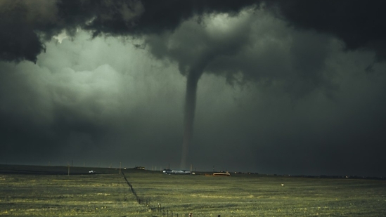
The National Weather Service reported that a tornado was seen from Fairmont, Minnesota, southwest of Minneapolis, and pea- to marble-sized hail fell in parts of Faribault County. Sheriff Scott Adams described the heavy rain saying, “It got really dark.”
The weather service also mentioned tornado watches were issued in southwestern Minnesota. Reports of tornadoes came from near Winnebago, Minnesota, but were not confirmed, and there was no damage reported.
Meteorologist Melissa Dye explained that some sightings may have been “gustnados”—small whirlwinds that can look like tornadoes but don’t actually connect to storm clouds. She said it would be hard to see a tornado because they would be hidden by rain.
In the Minneapolis-St. Paul area, the worst of the storms mostly missed them. By Monday evening, any serious threats were over for the metro area, although some storms were still active near Albert Lea, north of the Iowa border.
The Storm Prediction Center stated that less severe weather could affect parts of Texas and Oklahoma.
The first storms hit Minneapolis around 9 a.m., bringing heavy rain, but they didn’t cause any serious warnings. As a safety precaution, the City of Minneapolis closed its city facilities and activated its emergency response center. Many schools in Minneapolis, St. Paul, and Bloomington canceled evening events, and some schools in Iowa closed early.
As storms intensified in the afternoon, hail as large as 2.8 inches was reported near Beaver Creek, Minnesota. Tornado watches were put in place for nearly all of southern Minnesota and parts of northern Iowa and western Wisconsin, lasting until late Tuesday.
Additionally, on Sunday evening, a tornado caused an empty coal train to derail in northwestern Nebraska. Initial reports said the tornado was more than a mile wide and knocked many of the train’s cars over. Thankfully, no injuries were reported, and the locomotive stayed upright.


Leave a Reply